Aurland
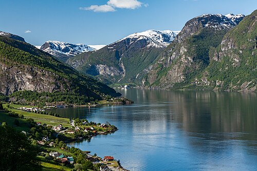
A fjord village with an old shoemaking tradition — a quieter base than Flåm, with the same view.
The facts
| Elevation | 5 m |
| Coordinates | 60.9057, 7.1880 |
| Time to allow | 3 h |
What to see
- Stegastein Viewpoint
- Aurlandsdalen Hike
- Aurlandskoen Sight
The penny loafer originates here, and is still stitched in the village.
Month by month
| Month | Daylight | Day high | Wet days | Access |
|---|---|---|---|---|
| January | 6.5 h | 0.6 °C | 17 | Open |
| February | 9.1 h | 0.7 °C | 14 | Open |
| March | 11.7 h | 3.2 °C | 15 | Open |
| April | 14.7 h | 7.4 °C | 13 | Open |
| May | 17.4 h | 11.9 °C | 15 | Open |
| June | 19.2 h | 16.9 °C | 17 | Open |
| July | 18.4 h | 20.3 °C | 18 | Open |
| August | 15.8 h | 19.3 °C | 18 | Open |
| September | 12.9 h | 15.1 °C | 15 | Open |
| October | 10.1 h | 8.8 °C | 16 | Open |
| November | 7.4 h | 3.4 °C | 15 | Open |
| December | 5.6 h | 0.9 °C | 17 | Open |
Background
Aurland (Urban East Norwegian: [ˈæ̂ʉrlɑn]) is a municipality in the county of Vestland, Norway. It is located on the south side of the Sognefjorden in the traditional district of Sogn. The administrative center is the village of Aurlandsvangen.
Source: Wikipedia (CC BY-SA)
On these routes
- Oslo–Bergen — The Bergen Line across Hardangervidda, with the Flåm Railway and Nærøyfjord along the way.
- Bergen–Trondheim — The fjords and Hardangervidda east to Oslo, then north over Dovrefjell to Nidaros.