Besseggen
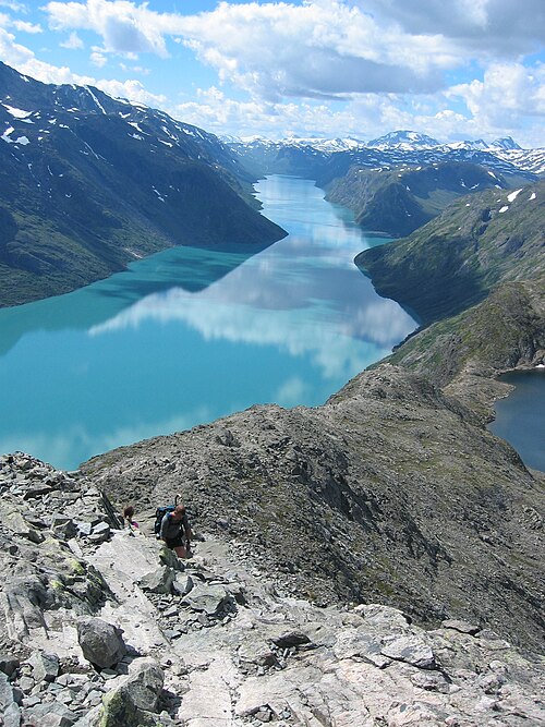
A ridge between two lakes of different colours: Lake Bessvatnet lies blue 400 metres above the green Gjende, and the path runs along the crest between them. Norway's most-walked mountain hike, with some 60,000 a year — and still one where people turn back at the steep pitch.
The facts
| Elevation | 1743 m |
| Coordinates | 61.5085, 8.7290 |
| Time to allow | 9 h |
What to see
- Besseggen Hike
14 kilometres and 1,100 metres of ascent, 6–8 hours. Boat to Memurubu first, then walk back. - Bessvatnet Viewpoint
A blue lake 400 metres above the green Gjende, and the whole point of the hike. - Veslfjellet Viewpoint
- Memurubu Sight
The walk
| Time to allow | 6–8 h |
| Distance | 14 km |
| Ascent | 1100 m |
| Difficulty | krevende |
| Season | Late June to mid-September, while the boat runs and the snow is off the ridge. Outside that season it is a winter route over ice. |
Besseggen takes 6–8 hours and 1,100 metres of ascent, and the boat sets your clock: the last sailing to Memurubu is 11:35, and if it goes without you the hike does not happen today. The ridge itself is a scramble where the steepest pitch is done with your hands, and it is unpleasant in rain or for anyone uneasy with heights. Carry food, water and windproofs — there is no kiosk between Memurubu and Gjendesheim.
In winter
The ridge is under snow, the boat does not run and the road in is shut. The route exists in winter, as a winter tour for the experienced with avalanche assessment — it has nothing to do with the summer walk.
Month by month
| Month | Daylight | Day high | Wet days | Access |
|---|---|---|---|---|
| January | 6.3 h | -11.2 °C | 14 | Closed |
| February | 9 h | -11.1 °C | 11 | Closed |
| March | 11.7 h | -8.2 °C | 12 | Closed |
| April | 14.7 h | -3.5 °C | 11 | Closed |
| May | 17.6 h | 0.8 °C | 12 | Closed |
| June | 19.4 h | 6 °C | 16 | Closed |
| July | 18.6 h | 9.9 °C | 18 | Open |
| August | 15.9 h | 8.5 °C | 17 | Open |
| September | 13 h | 4 °C | 14 | Open |
| October | 10.1 h | -2.3 °C | 14 | Closed |
| November | 7.2 h | -7.5 °C | 13 | Closed |
| December | 5.4 h | -10.5 °C | 13 | Closed |
Background
Besseggen is a mountain ridge in Vågå Municipality in Innlandet county, Norway. The 1,634-metre (5,361 ft) tall mountain ridge is located in the Jotunheimen mountains within Jotunheimen National Park. The mountain sits about 46 kilometres (29 mi) southwest of the village of Vågåmo and about 30 kilometres (19 mi) northwest of the village of Beitostølen.
Source: Wikipedia (CC BY-SA)
On these routes
- Otta–Flåm — Besseggen, Galdhøpiggen and the Sognefjell road — straight through Norway's high mountains, from the Dovre Line to the Bergen Line.