Otta–Flåm
Besseggen, Galdhøpiggen and the Sognefjell road — straight through Norway's high mountains, from the Dovre Line to the Bergen Line.
The facts
| stops | 13 |
| End to end | 10.5 h |
| Travel by | kollektiv, bil, buss |
| Home | Otta → Flåm |
When it is busy
| Month | When it is busy |
|---|---|
| January | 4 % |
| February | 7 % |
| March | 10 % |
| April | 13 % |
| May | 28 % |
| June | 57 % |
| July | 100 % |
| August | 79 % |
| September | 36 % |
| October | 13 % |
| November | 7 % |
| December | 5 % |
Busiest: July. Quietest: January. Guest arrivals per month as a share of the route's own busiest month. Figures from Statistics Norway, averaged over seven full years. They count people who stay overnight, so day trippers and cruise passengers are not included.
Stops along the way
- Otta · 0 h
The junction for Jotunheimen and Rondane — buses leave here for Norway's highest mountains. - Vågå · 0.5 h
The village where the road forks: south over Valdresflye to Lake Gjende and Besseggen, west to Lom and Galdhøpiggen. The stave church from 1130 was rebuilt as a cruciform church in the 1620s using timber from the old one — it is older than it looks. - Gjendesheim · 1.6 h
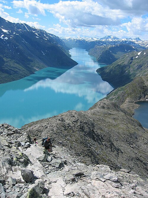
The DNT lodge at the eastern end of Lake Gjende, where Besseggen begins and ends. The water is green because the Muru river carries glacial silt into it — the colour is powdered rock, not algae, and it shifts with how fast the glacier melts. - Besseggen · 2.2 h
A ridge between two lakes of different colours: Lake Bessvatnet lies blue 400 metres above the green Gjende, and the path runs along the crest between them. Norway's most-walked mountain hike, with some 60,000 a year — and still one where people turn back at the steep pitch. - Lom · 3.4 h
The stave church from about 1160 is one of the largest still standing, and one of very few still in parish use — it holds services, not just tours. The village below is the base for Galdhøpiggen, and has the bakery people take the detour for. - Galdhøpiggen · 4.2 h
The highest mountain in Northern Europe outside the Caucasus, 2,469 metres. Two routes lead up, and they are not the same hike: from Juvasshytta the path crosses the Styggebreen glacier and requires a guide and a rope, while the Spiterstulen route is glacier-free but 1,470 metres of ascent and an hour longer each way. - Sognefjellet · 5.3 h
The highest paved mountain crossing in Northern Europe, 1,434 metres at its summit. The road was a packhorse trail carrying salt and fish between Sogn and Gudbrandsdalen for centuries before it opened to cars in 1938, and it runs through bare rock, snowfields and lakes that stay frozen well into June. - Turtagrø · 6 h
Where Norwegian mountaineering began: from here William Cecil Slingsby and his party climbed Store Skagastølstind in 1876, and the Hurrungane range above the hotel is still the country's densest cluster of peaks over 2,000 metres. The old hotel burned in 2001; what stands now was built to the same purpose. - Skjolden · 6.6 h
At the head of the Lustrafjord, which is at the head of the Sognefjord — 205 kilometres from the open sea, and so as far into the world's second-longest fjord as it is possible to get. Dropping from 1,434 metres on Sognefjellet to five metres here takes under an hour, and that is the whole of Norway in one drive. - Urnes stavkyrkje · 7.5 h
The oldest stave church still standing, built about 1130, and Norway's first entry on the UNESCO World Heritage list. The north portal is older than the church itself — reused from an eleventh-century building, its beasts and interlace carved in a style that took its name from this place. - Nigardsbreen · 8.4 h
An arm of the Jostedalsbreen, the largest glacier on mainland Europe. The ice reads blue because it is pressed so dense that every other colour is swallowed, and it has retreated more than two kilometres since the 1930s — marker stones along the path show where the front stood in which year. - Sogndal · 9.3 h
The regional centre of Sogn, with an airport, students and fruit farms on the slopes down to the fjord. From here the road continues to Flåm through the Lærdal Tunnel — the world's longest road tunnel at 24.5 kilometres, with blue-lit caverns along the way to keep drivers awake. - Flåm · 10.5 h
The Flåm Railway down to the Aurlandsfjord — 20 tunnels and a 5.5 % gradient over 20 km.