Galdhøpiggen
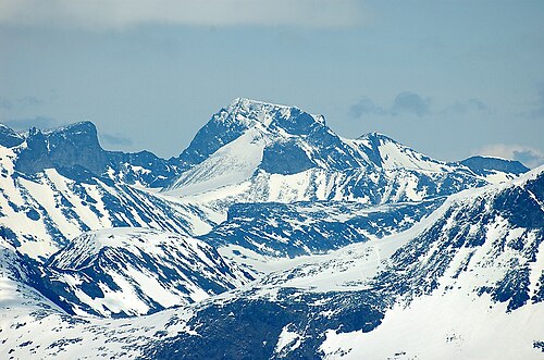
The highest mountain in Northern Europe outside the Caucasus, 2,469 metres. Two routes lead up, and they are not the same hike: from Juvasshytta the path crosses the Styggebreen glacier and requires a guide and a rope, while the Spiterstulen route is glacier-free but 1,470 metres of ascent and an hour longer each way.
The facts
| Elevation | 2469 m |
| Coordinates | 61.6364, 8.3125 |
| Time to allow | 9 h |
What to see
- Galdhøpiggen Hike
2,469 m, the highest in Northern Europe. Roped over the Styggebreen from Juvasshytta; glacier-free from Spiterstulen. - Galdhøpiggen Sommarskisenter Activity
A ski slope on the glacier, open May to November. Snow in summer, with no snow cannon. - Juvasshytta Sight
- Galdhøpigghytta Viewpoint
The walk
| Time to allow | 6–10 h |
| Distance | 13 km |
| Ascent | 850 m |
| Difficulty | krevende |
| Season | Mid-June to mid-September. The guided glacier crossing from Juvasshytta runs daily in season and only then; outside it, both routes are winter expeditions. |
Allow 6–8 hours from Juvasshytta and 8–10 from Spiterstulen. The Juvasshytta route cannot be walked alone: the Styggebreen glacier is crevassed, and the crossing is made roped together with a guide at fixed departure times — usually 10:00 and 11:30. The summit is at 2,469 metres, where it can be ten degrees colder and fully exposed to wind on a fine day down in the valley. A hat, gloves and windproofs are not excessive; they are what the hike requires.
In winter
The toll road to Juvasshytta closes for the winter and the guided glacier crossing runs only in season. The ski centre on Galdhøpiggen is exactly what its name says — a *summer* ski centre, shut in winter. The ascent from Spiterstulen is an avalanche-assessed winter tour.
Month by month
| Month | Daylight | Day high | Wet days | Access |
|---|---|---|---|---|
| January | 6.3 h | -14.9 °C | 16 | Closed |
| February | 9 h | -15.2 °C | 13 | Closed |
| March | 11.7 h | -13.1 °C | 14 | Closed |
| April | 14.8 h | -8.6 °C | 12 | Closed |
| May | 17.6 h | -4.5 °C | 13 | Closed |
| June | 19.5 h | 0.6 °C | 17 | Open |
| July | 18.6 h | 4.7 °C | 19 | Open |
| August | 15.9 h | 3.6 °C | 18 | Open |
| September | 13 h | -0.9 °C | 15 | Open |
| October | 10.1 h | -7.1 °C | 15 | Closed |
| November | 7.2 h | -11.8 °C | 14 | Closed |
| December | 5.4 h | -14.1 °C | 15 | Closed |
Background
Galdhøpiggen (Norwegian pronunciation: [ˈɡɑ̀ɫhøːˌpɪɡːən]) is the highest mountain in Norway, Scandinavia, and Northern Europe. The 2,469-metre-tall (8,100 ft) mountain is located in Lom Municipality in Innlandet county, Norway. It is in the Jotunheimen mountains within Jotunheimen National Park.
Source: Wikipedia (CC BY-SA)
On these routes
- Otta–Flåm — Besseggen, Galdhøpiggen and the Sognefjell road — straight through Norway's high mountains, from the Dovre Line to the Bergen Line.