Flåm
The Flåm Railway down to the Aurlandsfjord — 20 tunnels and a 5.5 % gradient over 20 km.
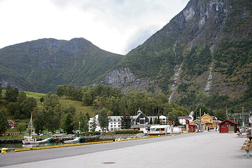
The facts
| Elevation | 2 m |
| Coordinates | 60.8632, 7.1144 |
| Time to allow | 5 h |
What to see
- Flåmsbana Sight
866 metres of climb in 20 km — one of the world's steepest adhesion railways. - Fjordcruise på Aurlandsfjorden Activity
- Flåmsbana Museum Museum
- Ægir Bryggeri Food
Month by month
| Month | Daylight | Day high | Wet days | Access |
|---|---|---|---|---|
| January | 6.5 h | 0.3 °C | 19 | Open |
| February | 9.1 h | 0.5 °C | 15 | Open |
| March | 11.7 h | 3.1 °C | 16 | Open |
| April | 14.7 h | 7.2 °C | 14 | Open |
| May | 17.4 h | 11.7 °C | 15 | Open |
| June | 19.2 h | 16.7 °C | 17 | Open |
| July | 18.3 h | 20.1 °C | 19 | Open |
| August | 15.8 h | 19.2 °C | 18 | Open |
| September | 12.9 h | 14.9 °C | 17 | Open |
| October | 10.1 h | 8.6 °C | 17 | Open |
| November | 7.4 h | 3.2 °C | 16 | Open |
| December | 5.6 h | 0.6 °C | 18 | Open |
Background
Flåm (Norwegian pronunciation: [floːm]) is a village in the Flåmsdalen valley which is located at the inner end of the Aurlandsfjorden, a branch of Sognefjorden. The village is located in Aurland Municipality in Vestland county, Norway. The 0.4-square-kilometre (99-acre) village has a population (2025) of 293 and a population density of 733 inhabitants per square kilometre (1,900/sq mi).
Source: Wikipedia (CC BY-SA)
On these routes
- Oslo–Bergen — The Bergen Line across Hardangervidda, with the Flåm Railway and Nærøyfjord along the way.
- Otta–Flåm — Besseggen, Galdhøpiggen and the Sognefjell road — straight through Norway's high mountains, from the Dovre Line to the Bergen Line.
- Bergen–Trondheim — The fjords and Hardangervidda east to Oslo, then north over Dovrefjell to Nidaros.