Lysebotn
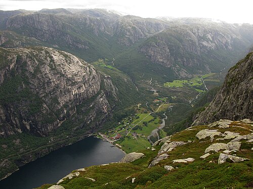
At the head of the Lysefjord, where the ferry docks and the Lyse road climbs 27 hairpins to 900 m — the last of them inside the mountain.
The facts
| Elevation | 5 m |
| Coordinates | 59.0548, 6.6453 |
| Time to allow | 2 h |
What to see
- Lysevegen Activity
27 hairpins up to 900 m, the last one inside the mountain. Closed in winter. - Kjerag Hike
- Lysebotn ferjekai Sight
In winter
Lysevegen with its 27 hairpins closes for the winter. Lysebotn is then reachable only by boat up the fjord, which is an entirely different day from a drive.
Month by month
| Month | Daylight | Day high | Wet days | Access |
|---|---|---|---|---|
| January | 7 h | 2.7 °C | 19 | Closed |
| February | 9.3 h | 2.4 °C | 16 | Closed |
| March | 11.8 h | 4.3 °C | 17 | Closed |
| April | 14.5 h | 8 °C | 14 | Closed |
| May | 16.9 h | 12.6 °C | 15 | Open |
| June | 18.5 h | 17.2 °C | 16 | Open |
| July | 17.8 h | 19.9 °C | 17 | Open |
| August | 15.5 h | 19.2 °C | 17 | Open |
| September | 12.9 h | 15.6 °C | 17 | Open |
| October | 10.3 h | 10.6 °C | 18 | Closed |
| November | 7.7 h | 6.1 °C | 18 | Closed |
| December | 6.2 h | 3.6 °C | 19 | Closed |
Background
Lysebotn is a village in Sandnes Municipality in Rogaland county, Norway. The village is located at the eastern end of the Lysefjorden in a very isolated valley that is only accessible by a seasonal road or by boat. The name itself means the "bottom [end] of the Lysefjorden".
Source: Wikipedia (CC BY-SA)
On these routes
- Stavanger–Bergen — The Pulpit Rock, Kjeragbolten and Trolltunga on one route — the three hikes people come to Norway for, and not one of them has a road to it.