Stavanger–Bergen
The Pulpit Rock, Kjeragbolten and Trolltunga on one route — the three hikes people come to Norway for, and not one of them has a road to it.
The facts
| stops | 21 |
| End to end | 15 h |
| Travel by | kollektiv, bil, buss |
| Home | Stavanger → Bergen |
When it is busy
| Month | When it is busy |
|---|---|
| January | 21 % |
| February | 25 % |
| March | 30 % |
| April | 31 % |
| May | 50 % |
| June | 74 % |
| July | 100 % |
| August | 93 % |
| September | 52 % |
| October | 34 % |
| November | 30 % |
| December | 22 % |
Busiest: July. Quietest: January. Guest arrivals per month as a share of the route's own busiest month. Figures from Statistics Norway, averaged over seven full years. They count people who stay overnight, so day trippers and cruise passengers are not included.
Stops along the way
- Stavanger · 0 h
The wooden-house city with Europe's best-preserved timber quarter and the oil museum on the quayside — and the starting point for the boats into the Lysefjord. - Jørpeland · 0.7 h
The Ryfylke industrial town where most Pulpit Rock trips begin — the last shop, fuel and bed before the path up. - Preikestolen · 1.2 h
A flat rock plateau, 25 by 25 metres, jutting 604 metres straight above the Lysefjord with no railing. Norway's most visited hike — around 300,000 people a year. - Lysefjorden · 2.5 h
42 kilometres of fjord between walls rising more than 1,000 metres straight out of the water, with the Pulpit Rock on one side and Kjerag on the other. - Flørli · 3.2 h
A disused power station with no road connection, and the world's longest wooden stairway: 4,444 steps beside the penstock, from the fjord to 740 m. - Lysebotn · 4 h
At the head of the Lysefjord, where the ferry docks and the Lyse road climbs 27 hairpins to 900 m — the last of them inside the mountain. - Kjeragbolten · 4.5 h
A five-cubic-metre boulder wedged in a crevice with a 984-metre vertical drop to the Lysefjord below. You step onto it unsecured, or you do not. - Sauda · 6.5 h
The smelter town at the head of the Sauda fjord, with the Åbødalen valley behind and an express boat to Stavanger — the hinge between Ryfylke and Hardanger. - Røldal · 7.6 h
The village below Haukelifjell with a 13th-century stave church — its crucifix was said to sweat every midsummer night, and pilgrims came to be healed. - Låtefossen · 8.1 h
Two waterfall arms meeting right above the Rv13 and dropping 165 metres into the river, past a six-arched stone bridge from 1859. The car gets wet. - Odda · 8.4 h
The industrial town at the head of the Sørfjord, known today mainly as the place you sleep before Trolltunga. Its smelter is a World Heritage candidate. - Tyssedal · 8.6 h
The 1906 power station that electrified Norway, cathedral-shaped beside the fjord — and the way in to Skjeggedal and Trolltunga. - Trolltunga · 9.5 h
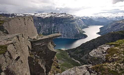
A shelf of gneiss jutting horizontally into the air 700 metres above Lake Ringedalsvatnet. Getting there is 27 kilometres and 1,200 metres of ascent — the hardest day hike in Norway that people attempt without experience. - Kinsarvik · 10.3 h
The ferry hub in the middle of Hardanger, with a 12th-century stone church and Husedalen behind it — four waterfalls in a row up towards Hardangervidda. - Eidfjord · 11 h
Where the Hardangerfjord ends and the plateau begins — a cruise port and the Hardangervidda Nature Centre. - Vøringsfossen · 11.4 h
A 182-metre free fall into the Måbødalen gorge, with a footbridge crossing straight over the lip. - Ulvik · 12 h
A fruit-growing village at the head of the Hardangerfjord — cider houses, apple blossom in May and still fjord water. - Voss · 12.8 h
Norway's extreme sports capital — rafting, paragliding and a cable car up Hangurstoppen from the centre. - Hardangerfjorden · 13.5 h
Norway's second-longest fjord — fruit farms along the waterline and the Folgefonna glacier on the far side. - Norheimsund · 14.2 h
Steinsdalsfossen, a waterfall you can walk behind, and the Hardanger Maritime Centre building wooden boats. - Bergen · 15 h
Bryggen, the fish market and seven mountains — the natural end of the journey.