Tyssedal
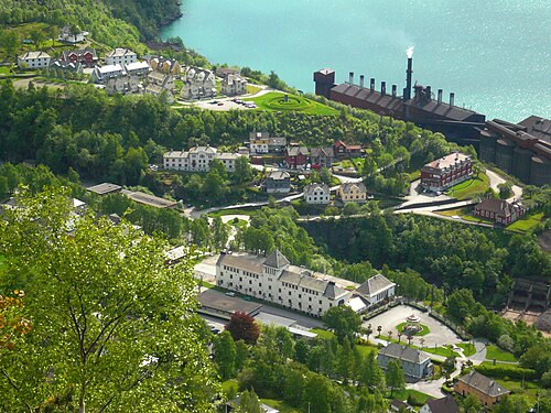
The 1906 power station that electrified Norway, cathedral-shaped beside the fjord — and the way in to Skjeggedal and Trolltunga.
The facts
| Elevation | 15 m |
| Coordinates | 60.1163, 6.5591 |
| Time to allow | 2 h |
What to see
- Norsk vasskraft- og industristadmuseum Museum
- Tyssedal kraftstasjon Sight
- Ringedalsvatnet Hike
Month by month
| Month | Daylight | Day high | Wet days | Access |
|---|---|---|---|---|
| January | 6.7 h | 1.8 °C | 20 | Open |
| February | 9.2 h | 1.6 °C | 17 | Open |
| March | 11.8 h | 3.8 °C | 18 | Open |
| April | 14.6 h | 7.7 °C | 15 | Open |
| May | 17.2 h | 11.9 °C | 16 | Open |
| June | 18.9 h | 16.5 °C | 17 | Open |
| July | 18.1 h | 19.6 °C | 20 | Open |
| August | 15.7 h | 19.3 °C | 19 | Open |
| September | 12.9 h | 15.5 °C | 18 | Open |
| October | 10.2 h | 9.5 °C | 18 | Open |
| November | 7.5 h | 4.6 °C | 18 | Open |
| December | 5.9 h | 2.5 °C | 19 | Open |
Background
Tyssedal is a village in Ullensvang Municipality in Vestland county, Norway. The village is located on the shore of the Sørfjorden about 6 kilometres (3.7 mi) north of the town of Odda. Tyssedal is located in an environment in a valley between the fjord to the west and the mountains leading up to the Hardangervidda mountain plateau to the east.
Source: Wikipedia (CC BY-SA)
On these routes
- Stavanger–Bergen — The Pulpit Rock, Kjeragbolten and Trolltunga on one route — the three hikes people come to Norway for, and not one of them has a road to it.