Preikestolen
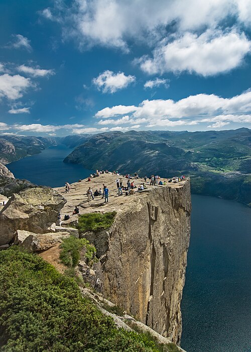
A flat rock plateau, 25 by 25 metres, jutting 604 metres straight above the Lysefjord with no railing. Norway's most visited hike — around 300,000 people a year.
The facts
| Elevation | 604 m |
| Coordinates | 58.9864, 6.1904 |
| Time to allow | 5 h |
What to see
- Preikestolen Hike
8 kilometres and 350 metres of ascent from the lodge and back. Allow 4–5 hours. - Preikestolen Viewpoint
- Preikestolen BASE Activity
The plateau is one of the world's best-known BASE-jumping exits — to watch, not to try.
The walk
| Time to allow | 4–5 h |
| Distance | 8 km |
| Ascent | 350 m |
| Difficulty | moderat |
| Season | April to October without winter kit. In winter the path is iced and snow-covered, and crampons or a guide are needed. |
Allow 4–5 hours round trip, and start early: 8 kilometres and 350 metres of ascent over boulders and bog, with queues in high season. The path is unlit, and the last bus down leaves earlier than people expect.
In winter
The path is open all year, but from November to April it is ice and snow over bare rock, and that is when people slip. Guided winter hikes run from the mountain lodge and have become a season of their own.
Month by month
| Month | Daylight | Day high | Wet days | Access |
|---|---|---|---|---|
| January | 7 h | -1.4 °C | 19 | Open |
| February | 9.3 h | -1.3 °C | 16 | Open |
| March | 11.8 h | 0.6 °C | 17 | Open |
| April | 14.5 h | 5 °C | 15 | Open |
| May | 16.9 h | 9.9 °C | 16 | Open |
| June | 18.5 h | 13 °C | 16 | Open |
| July | 17.8 h | 15 °C | 18 | Open |
| August | 15.5 h | 14.6 °C | 18 | Open |
| September | 12.9 h | 11.2 °C | 17 | Open |
| October | 10.3 h | 6.5 °C | 18 | Open |
| November | 7.7 h | 2.2 °C | 17 | Open |
| December | 6.2 h | -0.5 °C | 19 | Open |
Background
Preikestolen or Prekestolen (English: 'Pulpit Rock' or 'Pulpit') is a tourist attraction in Strand Municipality in Rogaland county, Norway. Preikestolen is a steep cliff which rises 604 metres (1,982 ft) above Lysefjorden. Atop the cliff, there is an almost flat top of approximately 25 by 25 metres (82 ft × 82 ft).
Source: Wikipedia (CC BY-SA)
On these routes
- Stavanger–Bergen — The Pulpit Rock, Kjeragbolten and Trolltunga on one route — the three hikes people come to Norway for, and not one of them has a road to it.