Ulvik
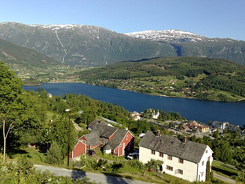
A fruit-growing village at the head of the Hardangerfjord — cider houses, apple blossom in May and still fjord water.
The facts
| Elevation | 5 m |
| Coordinates | 60.5676, 6.9187 |
| Time to allow | 3 h |
What to see
- Siderruta i Ulvik Food
The orchards here make cider with protected origin status, like champagne. - Hardangerfjorden Sight
Month by month
| Month | Daylight | Day high | Wet days | Access |
|---|---|---|---|---|
| January | 6.6 h | 0.8 °C | 19 | Open |
| February | 9.1 h | 0.7 °C | 16 | Open |
| March | 11.7 h | 3.1 °C | 17 | Open |
| April | 14.6 h | 7.3 °C | 14 | Open |
| May | 17.3 h | 11.8 °C | 15 | Open |
| June | 19 h | 16.8 °C | 17 | Open |
| July | 18.2 h | 19.9 °C | 18 | Open |
| August | 15.7 h | 19 °C | 17 | Open |
| September | 12.9 h | 14.7 °C | 16 | Open |
| October | 10.2 h | 8.7 °C | 17 | Open |
| November | 7.4 h | 3.8 °C | 16 | Open |
| December | 5.7 h | 1.5 °C | 18 | Open |
Background
Ulvik is a municipality in Vestland county, Norway. It is located in the traditional district of Hardanger. The municipality stretches from the Hardangerfjord to the mountains that reach 1,800 metres (5,900 ft) above sea level.
Source: Wikipedia (CC BY-SA)
On these routes
- Oslo–Bergen — The Bergen Line across Hardangervidda, with the Flåm Railway and Nærøyfjord along the way.
- Stavanger–Bergen — The Pulpit Rock, Kjeragbolten and Trolltunga on one route — the three hikes people come to Norway for, and not one of them has a road to it.
- Bergen–Trondheim — The fjords and Hardangervidda east to Oslo, then north over Dovrefjell to Nidaros.