Trolltunga
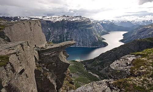
A shelf of gneiss jutting horizontally into the air 700 metres above Lake Ringedalsvatnet. Getting there is 27 kilometres and 1,200 metres of ascent — the hardest day hike in Norway that people attempt without experience.
The facts
| Elevation | 1180 m |
| Coordinates | 60.1242, 6.7400 |
| Time to allow | 12 h |
What to see
- Trolltunga Hike
27 kilometres and 1,200 metres of ascent round trip. Takes 8–12 hours, and an early start. - Trolltunga Viewpoint
- Trolltunga Via Ferrata Activity
A secured climbing route up the wall below the tongue, with a guide — an alternative to the path. - Ringedalsdammen Sight
The walk
| Time to allow | 8–12 h |
| Distance | 27 km |
| Ascent | 1200 m |
| Difficulty | krevende |
| Season | 15 June to 15 September without a guide. Outside the season snow covers the path, the markers are gone, and the hike requires a guide and winter kit. |
Trolltunga demands 8–12 hours of hard hiking: 27 kilometres round trip and 1,200 metres of ascent, with no quick way back once you are halfway. Start by eight at the latest, carry food, water, windproofs and a head torch, and expect a queue for the photograph on the tongue itself. Every year unprepared walkers are brought down by mountain rescue.
In winter
Out of season Trolltunga is a winter expedition and goes with a guide only — on skis or snowshoes, with avalanche assessment along the way. The trip gets longer, not shorter: the road up to Mågelitopp is shut.
Month by month
| Month | Daylight | Day high | Wet days | Access |
|---|---|---|---|---|
| January | 6.7 h | -5.9 °C | 20 | Closed |
| February | 9.2 h | -6.1 °C | 16 | Closed |
| March | 11.8 h | -3.9 °C | 17 | Closed |
| April | 14.6 h | 0 °C | 15 | Closed |
| May | 17.2 h | 4 °C | 15 | Closed |
| June | 18.9 h | 8.9 °C | 17 | Open |
| July | 18.1 h | 12.1 °C | 19 | Open |
| August | 15.7 h | 11.8 °C | 19 | Open |
| September | 12.9 h | 7.8 °C | 17 | Open |
| October | 10.2 h | 1.7 °C | 18 | Closed |
| November | 7.5 h | -3.1 °C | 18 | Closed |
| December | 5.9 h | -5.1 °C | 19 | Closed |
Background
Trolltunga (lit. 'the troll tongue') is a rock formation situated at an elevaton of 1,126 metres (3,694 ft) above sea level in Ullensvang Municipality in Vestland county, Norway. The cliff juts horizontally out from the mountain, about 700 metres (2,300 ft) above the north side of the lake Ringedalsvatnet. Popularity of the hike to Trolltunga and rock formation itself has exploded in recent years.
Source: Wikipedia (CC BY-SA)
On these routes
- Stavanger–Bergen — The Pulpit Rock, Kjeragbolten and Trolltunga on one route — the three hikes people come to Norway for, and not one of them has a road to it.