Mo i Rana
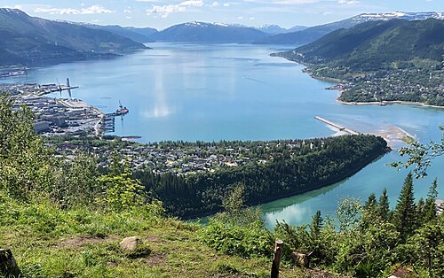
The industrial town that is the gateway to the Svartisen glacier and to Grønligrotta, Norway's best-known limestone cave.
The facts
| Elevation | 10 m |
| Coordinates | 66.3096, 14.1335 |
| Time to allow | 4 h |
What to see
- Grønligrotta Activity
- Setergrotta Activity
- Havmannen Sight
- Svartisen Hike
Month by month
| Month | Daylight | Day high | Wet days | Access |
|---|---|---|---|---|
| January | 4.4 h | -3.9 °C | 17 | Open |
| February | 8.3 h | -4.3 °C | 15 | Open |
| March | 11.7 h | -1.6 °C | 16 | Open |
| April | 15.4 h | 2.9 °C | 14 | Open |
| May | 19.3 h | 7.4 °C | 16 | Open |
| June | Midnight sun | 13.7 °C | 16 | Open |
| July | 21.2 h | 17.7 °C | 16 | Open |
| August | 16.9 h | 16.4 °C | 17 | Open |
| September | 13.2 h | 11.6 °C | 17 | Open |
| October | 9.6 h | 4.7 °C | 16 | Open |
| November | 5.8 h | -0.1 °C | 16 | Open |
| December | 2.6 h | -2.2 °C | 18 | Open |
Background
Mo i Rana or Måefie (Southern Sami) (and unofficially Ume Sami: Måhvie, Northern Sami: Muoffie) is a city, and the administrative centre of Rana Municipality in Nordland county, Norway. It is located in the Helgeland region of Nordland, just south of the Arctic Circle.
Source: Wikipedia (CC BY-SA)
On these routes
- Trondheim–Bodø — The Nordland Line crosses the Arctic Circle — ten hours north to Saltstraumen.
- Oslo–Tromsø — The length of the country: Dovrefjell, the Arctic Circle, Lofoten, and finally the aurora over Tromsø.
- Oslo–Bodø — From the capital across Dovrefjell and past the Arctic Circle to Saltstraumen.