Oslo–Tromsø
The length of the country: Dovrefjell, the Arctic Circle, Lofoten, and finally the aurora over Tromsø.
The facts
| stops | 49 |
| End to end | 30.4 h |
| Travel by | kollektiv, bil, buss |
| Home | Oslo → Tromsø |
When it is busy
| Month | When it is busy |
|---|---|
| January | 26 % |
| February | 33 % |
| March | 37 % |
| April | 29 % |
| May | 37 % |
| June | 69 % |
| July | 100 % |
| August | 77 % |
| September | 46 % |
| October | 37 % |
| November | 34 % |
| December | 28 % |
Busiest: July. Quietest: January. Guest arrivals per month as a share of the route's own busiest month. Figures from Statistics Norway, averaged over seven full years. They count people who stay overnight, so day trippers and cruise passengers are not included.
Stops along the way
- Oslo · 0 h
Start in the capital — the Opera House, Akershus Fortress and Vigeland Park before the train heads west. - Hamar · 1.2 h
The town on Lake Mjøsa — the cathedral ruins under a glass vault and a skating hall shaped like an upturned Viking ship. - Lillehammer · 2.2 h
The 1994 Olympic town, with Norway's steepest pedestrian street and a ski jump hanging over the centre. - Maihaugen · 2.3 h
Scandinavia's largest open-air museum — 200 buildings, from a stave church to a complete 1980s apartment block. - Ringebu · 2.9 h
A stave church from 1220 with a red spire, in the narrowest stretch of the Gudbrandsdalen valley. - Vinstra · 3.2 h
Peer Gynt country — Ibsen took the character from a farmer said to have lived in these valley sides. - Otta · 3.6 h
The junction for Jotunheimen and Rondane — buses leave here for Norway's highest mountains. - Rondane · 4 h
Norway's first national park, ten peaks above 2000 metres, and the light that made Sohlberg paint "Winter Night in the Mountains". - Dombås · 4.1 h
Where the Rauma Line branches off towards Åndalsnes and the Troll Wall — a junction on the edge of Dovrefjell. - Hjerkinn · 4.4 h
Norway's driest place, 1017 m up on Dovrefjell — the starting point for musk ox safaris. - Viewpoint Snøhetta · 4.6 h
A wind-sculpted timber pavilion on the plateau, framing Snøhetta at 2286 m through one panoramic window — half an hour's walk from the road. - Dovrefjell · 4.5 h
A national park with Europe's last wild musk oxen and reindeer — the mountain Norway's constitution swore by. - Kongsvoll · 4.7 h
An 18th-century mountain lodge at the source of the Driva, ringed by a botanical garden of arctic plants. - Oppdal · 5.1 h
A ski destination and Viking burial ground — over 900 grave mounds lie in the pine forest at Vang. - Røros · 5 h
A UNESCO-listed mining town of tar-brown timber houses and slag heaps — 333 years of copper. Reached on the Røros Line. - Støren · 5.9 h
Where the Røros Line rejoins the Dovre Line, in the Gauldalen valley with its salmon river and steep sides. - Nidarosdomen · 6.7 h
Scandinavia's largest medieval cathedral, built over St Olav's grave and the end of the pilgrim route. - Trondheim · 6.6 h
The wharves along the Nidelva, the bicycle lift up Brubakken, and Norway's oldest university city. - Steinkjer · 8.6 h
At the head of the Trondheimsfjord, with Bronze Age rock carvings at Bølareinen just outside town. - Snåsa · 9.5 h
The heart of South Sámi Norway, with its own language centre, and Lake Snåsavatnet lying still between forested ridges. - Grong · 10.3 h
The Namsen, "queen of salmon rivers", and the Fiskum falls where a fish ladder lets you watch the salmon climb. - Mosjøen · 12.6 h
Sjøgata — northern Norway's longest unbroken row of 19th-century timber houses, and a zipline down from Øyfjellet. - Mo i Rana · 13.8 h
The industrial town that is the gateway to the Svartisen glacier and to Grønligrotta, Norway's best-known limestone cave. - Svartisen · 14.6 h
Norway's second-largest glacier. The Engabreen arm pushes down towards Holandsfjorden and ends barely 20 metres above sea level. - Polarsirkelen · 14.6 h
66°33′ north, marked by cairns on the Saltfjellet plateau. North of here the sun does not set at midsummer. - Lønsdal · 14.8 h
The high-mountain station right at the Arctic Circle — the way into Saltfjellet–Svartisen National Park. - Rognan · 15.5 h
At the head of the Saltdalsfjord, with a boatbuilding tradition and the Blood Road Museum on the prisoners who built the road. - Fauske · 15.8 h
The marble town — its pink Norwegian marble lines the UN building in New York. The bus north to Narvik starts here. - Saltstraumen · 16.4 h
The world's strongest tidal current — 400 million cubic metres of water forced through a 150-metre strait four times a day. - Bodø · 16.4 h
European Capital of Culture 2024, the end of the railway and the ferry port for Lofoten. - Moskenes · 19.9 h
The ferry berth where Lofoten begins — three hours across the Vestfjord from Bodø, the peaks rising straight out of the sea. - Å i Lofoten · 20.2 h
The last place on the road and the last letter of the Norwegian alphabet — stockfish racks, fishermen's cabins and the Norwegian Fishing Village Museum. - Reine · 20.4 h
Red cabins on a spit in the Reinefjord, with Olstinden rising 700 metres directly behind — Norway's most photographed fishing village. - Hamnøy · 20.5 h
Lofoten's oldest fishing village. The bridge here gives the photograph everyone knows: cabins in the foreground, Festhelltinden behind. - Reinebringen · 20.6 h
1566 sherpa-built stone steps to 448 m, looking straight down on Reine and the fjord arms between the peaks. - Nusfjord · 21.2 h
One of Norway's best-preserved fishing villages, near-unchanged since the 1800s, in a harbour so narrow it is barely visible from the road. - Ballstad · 21.6 h
One of Lofoten's largest working fishing villages — the trade as it actually is, rather than as a museum. - Leknes · 21.8 h
Vestvågøy's commercial centre and practical hub — airport, shops and buses onward in every direction. - Haukland · 22.1 h
White sand and turquoise water beneath 400-metre peaks — Arctic Caribbean, with the water topping out around 12 °C. - Lofotr vikingmuseum · 22.4 h
A reconstruction of the largest chieftain's longhouse found in Scandinavia — 83 metres long, built over the excavation at Borg. - Henningsvær · 23.2 h
A fishing village spread across several islets and linked by bridges — and a football pitch wedged between the stockfish racks. - Svolvær · 23.7 h
Lofoten's capital, with the Svolvær Goat rock pinnacle over the town and boats out to the Trollfjord. - Stokmarknes · 25 h
Birthplace of the Hurtigruten coastal express. Its museum has the entire MS Finnmarken standing on dry land, under a roof. - Sortland · 25.7 h
"The blue town" — the houses were painted in shades of blue as an art project, and the colour stuck. - Andenes · 27.4 h
At the far tip of Andøya, where the continental shelf drops away and sperm whales gather — whale safaris all summer. - Harstad · 27.2 h
Northern Norway's second city, with the 13th-century Trondenes church and a German coastal battery holding the world's largest land-based guns. - Finnsnes · 29 h
The bridge across to Senja, "Norway in miniature" — and the last stop before the run into Tromsø. - Fløya · 30.6 h
The cable car lifts you to 421 m in four minutes; the path continues to 671. From here the midnight sun stands over the whole of Tromsøya. - Tromsø · 30.4 h
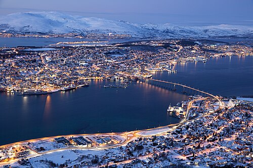
The world's northernmost university city — the Arctic Cathedral, polar history, and the aurora directly over the centre from September to March.