Oppdal
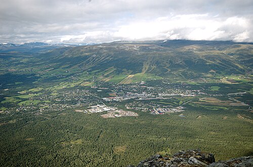
A ski destination and Viking burial ground — over 900 grave mounds lie in the pine forest at Vang.
The facts
| Elevation | 545 m |
| Coordinates | 62.5931, 9.6940 |
| Time to allow | 4 h |
What to see
- Oppdal skisenter Activity
- Trollheimen Hike
- Gjevilvassdalen Hike
Month by month
| Month | Daylight | Day high | Wet days | Access |
|---|---|---|---|---|
| January | 6 h | -4.7 °C | 13 | Open |
| February | 8.9 h | -3.8 °C | 11 | Open |
| March | 11.7 h | -0.5 °C | 12 | Open |
| April | 14.9 h | 4.3 °C | 12 | Open |
| May | 17.9 h | 8.6 °C | 14 | Open |
| June | 20 h | 13.2 °C | 17 | Open |
| July | 19 h | 16.5 °C | 18 | Open |
| August | 16.1 h | 15.4 °C | 16 | Open |
| September | 13 h | 11.2 °C | 13 | Open |
| October | 10 h | 4.8 °C | 13 | Open |
| November | 7 h | -0.9 °C | 11 | Open |
| December | 5 h | -4.2 °C | 12 | Open |
Background
Oppdal () is a municipality in Trøndelag county, Norway. It is part of the Dovre region. The administrative centre of the municipality is the village of Oppdal.
Source: Wikipedia (CC BY-SA)
On these routes
- Oslo–Trondheim — The Dovre Line through Gudbrandsdalen and over Dovrefjell, home to Norway's musk oxen.
- Oslo–Tromsø — The length of the country: Dovrefjell, the Arctic Circle, Lofoten, and finally the aurora over Tromsø.
- Oslo–Bodø — From the capital across Dovrefjell and past the Arctic Circle to Saltstraumen.
- Bergen–Trondheim — The fjords and Hardangervidda east to Oslo, then north over Dovrefjell to Nidaros.